Remark: Here ![]() is not exactly the "geographical
latitude". It is zero at the "North Pole" (
is not exactly the "geographical
latitude". It is zero at the "North Pole" (![]() ),
), ![]() degrees at the equator, and
degrees at the equator, and ![]() degrees at the "South Pole"
(
degrees at the "South Pole"
(![]() ).
).
Each map
![]() maps the sphere onto itself in an
injective way. For
maps the sphere onto itself in an
injective way. For
![]() the map is easy to picture. All
points of the sphere move towards the North Pole along their
meridians, except of the two fixed points: North and South Pole.
All of the Northern hemisphere, and a strip below the equator,
shrinks, while the other part, near the South Pole, stretches.
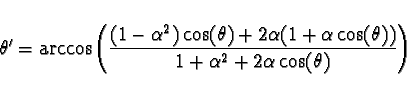
The amount of stretching can be found by plotting the function
the map is easy to picture. All
points of the sphere move towards the North Pole along their
meridians, except of the two fixed points: North and South Pole.
All of the Northern hemisphere, and a strip below the equator,
shrinks, while the other part, near the South Pole, stretches.
The amount of stretching can be found by plotting the function
![]() - it has a maximum at
- it has a maximum at ![]() corresponding to
corresponding to ![]() . Thus the parameter
. Thus the parameter ![]() gets a
simple interpretation: it is the value of
gets a
simple interpretation: it is the value of ![]() coordinate for which
shrinking of meridians is replaced by stretching - an equilibrium
point. This point is always on the southern hemisphere. For
coordinate for which
shrinking of meridians is replaced by stretching - an equilibrium
point. This point is always on the southern hemisphere. For
![]() close to zero, where the map is close to the identity
map, the equilibrium point is close to the equator. Then, as
close to zero, where the map is close to the identity
map, the equilibrium point is close to the equator. Then, as
![]() approaches the value of
approaches the value of ![]() , corresponding to the
sharp projection operator, the equilibrium latitude gets closer
and closer to the South Pole. In the limit of
, corresponding to the
sharp projection operator, the equilibrium latitude gets closer
and closer to the South Pole. In the limit of ![]() all of
the sphere shrinks to the North Pole, only the South Pole remains
where it was.
all of
the sphere shrinks to the North Pole, only the South Pole remains
where it was.